Local Walks
Please have a look at the Countryside Access Map for Hurstbourne Tarrant Parish.
(Please note that this map will take 15-20 seconds to download.)
Useful information links for local walking:
Links to 'Walking in Hampshire' - Link , Walks in the Andover Area Link
HCC Walking Strategy Document Link
TVBC link to 'Cycling and Walking in the beautiful Test Valley' Link
North Wessex Area of Outstanding Natural Beauty Link
Hampshire County Council - Parish Guide LINK
To report a problem on the Rights of Way network to HCC please use their online reporting system which can be found here
Hampshire County Council operates a Small Grants Scheme, enabling parishes to apply for funding towards a project to improve or promote countryside access and Rights of Way. More information can be found here.
Get to know some most popular long distance paths in or near the parish:
The Brenda Parker Way
A new long distance path has been created, using existing rights of way, named in memory of Brenda Parker. Link
The Wayfarers Way
The Wayfarers Walk extends 70 miles between the coast near Portsmouth and Inkpen Beacon just across the Berkshire border. It connects with other long distance paths at Emsworth (the Sussex Border Path), at Bedhampton (the Solent Way) and at Inkpen Beacon (the Test Way). The area is very popular with walkers due to the beautiful views of unspoilt countryside.
Start - Inkpen Beacon - Burghclere - North Oakley - Deane - Dummer - Brown Candover - New Alresford - Cheriton - Droxford - Hambledon - Denmead - Bedhampton - Emsworth - End Link
The Test Way:
A 44 mile long-distance walking route takes you from its dramatic start, high on the chalk downs at Inkpen, to follow much of the course of the River Test to Eling where its tidal waters flow into Southampton Water. This is without doubt Hampshire's longest and finest chalk stream, world famous for its superb trout fishing. Link
Inkpen to Hurstbourne Tarrant
Distance: 8 miles Time: 3-4 hours
The Test Way begins high on a dramatic chalk escarpment at Inkpen. From here you can see the bleak downs to the north and the lush plain to the south. On a fine day you may even glimpse the soaring landmark of Salisbury Cathedral’s spire. From here the trail drops sharply to the valley and rises to the small village of Linkenholt, then follows farm tracks to the pretty hamlet of Ibthorpe, where Jane Austen was a regular visitor at Ibthorpe House. The path then follows alongside the bed of a winterbourne (a seasonally rising stream) into the village of Hurstbourne Tarrant – a favourite of William Cobbett, author of ‘Rural Rides’.
Hurstbourne Tarrant to St Mary Bourne
Distance: 3 miles Time: 1-2 hours
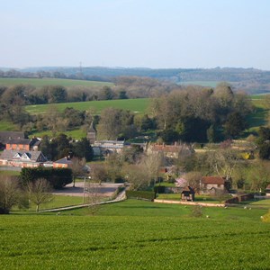
In Hurstbourne Tarrant the path runs through the village, crosses the valley and heads steeply uphill to the copses of Wallop Hill Down where you can look back for a postcard view of the village nestling below. Gently descend past Stokehill Farm to St Mary Bourne which straggles alongside the course of the Bourne Rivulet where the 12th C church contains several treasures. Look downstream for the huge nine-arch viaduct at Hurstbourne Priors and the numerous watercress beds.
Basingstoke Ramblers Club
Basingstoke Ramblers Club is a group of some 200 people of all ages and fitness levels who walk three times a week and occasionally go away for a weekend or holiday excursion. Most walks are about 6 to 8 miles, some are a little further and include a pub stop. Link


